Figure 1: Region #1 street segments and local community physical activity (PA) resources
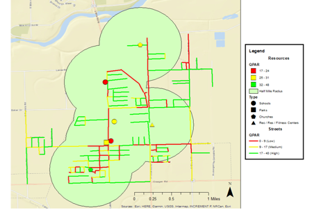
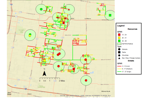
Figure 2: Region #2 street segments and local community physical activity (PA) resources
Beyond Walking: An Assessment and Description of Streets as Potential Physical Activity Places in Low-Income Communities
M. Renée Umstattd Meyer1, Tyler Prochnow1,2, Kelly R. Ylitalo1, Luis Gómez2, and Joseph R. Sharkey2
1 Baylor University, Robbins College of Health and Human Sciences, Department of Public Health, U.S.A.
2 Texas A&M University, School of Public Health, Department of Health Behavior, U.S.A.
Abstract
Low-income communities often have fewer quality community-level physical activity places (PAPs) or resources (e.g., parks, playgrounds). When present, barriers like traffic, distance, and crime often prevent access. Creative solutions and better understanding of current and potential realistic PAPs are necessary for children and families to be active. Streets are rarely considered potential PAPs despite their ubiquity and accessibility. This article describes street segments as potential PAPs in two low-income Mexican-heritage colonias communities along the Texas-Mexico border. Promotora-researchers conducted PAP assessments of all street segments (n=867) in the two communities to describe the availability and quality of their physical activity features (e.g., basketball hoops, bicycles), amenities (e.g., paved driveways, yard space), and incivilities (e.g., vandalism, loose dogs). Streets in these communities did contain features and amenities associated with physical activity promotion. On average, street segments had 6.10 (SD=7.20) physical activity-promoting features, 27.65 (SD=27.30) physical activity-promoting amenities, and both were assessed as good-to-fair quality. Future physical activity programming should consider incorporating streets as potential PAPs to enhance physical activity and active play. Further, evaluating streets as PAPs in this way may provide insight into locations for temporary place-based programs such as Play Streets. Future research should also examine residents’ perceptions of their streets as PAPs for safe physical activity and active play, not just as places to walk, and which PAP characteristics matter for safe physical activity and active play to occur on streets.
Keywords: under-resourced, environmental audit, resources, Mexican-heritage, active living, active play
Physical activity (PA) is related to many health benefits including reduced risk of obesity, diabetes, and other chronic diseases (Janssen & LeBlanc, 2010). Regular PA has been favorably associated with psychological and social health indicators for children, including increased academic achievement and cognitive functioning, as well as lower anxiety and depression (Janssen & LeBlanc, 2010). Despite known benefits of PA, only 26.1% of U.S. children meet the national recommendation of 60 minutes of PA per day (Kann et al., 2018). Evidence indicates that adults and youth with lower-incomes are less likely to achieve recommended levels of PA than those with greater income levels, with the largest disparities for those that are poor (< 200% of the poverty threshold) or near poor (100%-200% of the poverty threshold) compared to those not poor (≥ 200% of the poverty threshold) (Armstrong et al., 2018; Villarroel, Blackwell, & Jen, 2019). This disparity may be due to barriers to PA including a lack of transportation, lack of access to quality facilities (e.g., parks, community/recreation centers, gyms, pedestrian/bicycle facilities) and/or equipment, fees for facility use, and perceived safety (e.g., crime, traffic), which have been shown to disproportionately affect low-income/low-resource neighborhoods and communities (Bantham, Taverno Ross, Sebastião, & Hall, 2021; Sallis et al., 2011).
Residents residing in colonias along the border of Texas and Mexico face notable barriers to accessing PA resources. Colonias are defined as economically distressed communities consisting of low or very low-income households based on the Federal poverty index. Colonias are located at or near the U.S.-Mexico border area with an outer range stretching from 50–150 miles into the U.S. (Donelson & Esparza, 2010). According to the U.S. Department of Health and Human Services, the U.S.-Mexico border region is a medically underserved area that has increased social and health barriers, increased rates of poverty, and disproportionate rates of disease (Office of Global Affairs, 2017).
Families residing in colonias face multidimensional challenges which highlight the importance of understanding available PA resources, both from a traditional sense (e.g., parks, playgrounds) and more innovative perspectives. Due to a lack of traditional and more permanent PA resources in colonias, creative solutions are vital to effectively support PA for children and families residing in these communities (Donelson & Esparza, 2010). One potential solution to supporting PA for low-income residents is to consider streets as a potential place where PA can take place - a PA place (PAP). Communities worldwide, including those in urban, suburban, and rural communities in the U.S., have started using streets as PAPs by closing the streets temporarily to vehicle traffic to allow families to be physically active in a safe, controlled atmosphere (Kuhlberg, Hipp, Eyler, & Chang, 2014; Perry, Ko, Hernandez, Ortiz, & Linde, 2017; M. R. Umstattd Meyer, Bridges, Schmid, Hecht, & Pollack Porter, 2019; Umstattd Meyer, Bridges Hamilton, et al., 2019).
When attempting to describe streets as PAPs, current methods focus on assessing street segments in the context of active transportation and walkability (e.g., connectivity, aesthetics, and safety) (Clifton, Smith, & Rodriguez, 2007; Hoehner, Ivy, Ramirez, Handy, & Brownson, 2007). While active transportation-focused characteristics are important for the promotion of PA, streets and bordering yards are rarely assessed as potential places for other PA or active play to occur outside of active transportation, despite their ubiquity, accessibility, and proximity to homes. The Physical Activity Resource Assessment (PARA) (Lee, Booth, Reese-Smith, Regan, & Howard, 2005) has been used to assess the amenities, features, and incivilities of many permanent community PAPs such as schools, churches, playgrounds, parks, trails, and community resource centers, but to date has not been used to assess streets as potential PAPs (DeBate et al., 2011).
The purpose of this study was first, to describe an innovative approach to conceptualizing and assessing streets as potential PAPs in low-income communities, beyond active transportation. Viewing streets as potential PAPs beyond active transportation and assessing them as such could provide researchers and practitioners a more complete view of the PAPs and resources available to facilitate PA within a community. A second aim was to describe the results of this assessment and paint a picture of what street segments look like in terms of PAP characteristics in low-income communities.
Materials and Methods
Setting
This study was conducted as part of the larger Salud Para Usted y Su Familia (SPUSF) [Health for You and Your Family] research, education, and outreach project along the Texas-Mexico border areas of Hidalgo County, Texas funded by the USDA NIFA. Street assessments were completed in two low-income colonias regions including portions of smaller towns and many unincorporated areas. These regions were selected based on previous and ongoing work in the Lower Rio Grande Valley and Texas-Mexico border area to better understand factors that may support and/or deter PA. Characteristics of each region are displayed in Table 1.
Table 1. Characteristics of Study Regions
|
Characteristics |
Region #1 |
Region #2 |
|
Population |
5,826 |
3,112 |
|
Median Annual Household Income |
$43,400 |
$21,500 |
|
% of Adults with High School Diploma or GED |
52.2% |
35.2% |
|
% School-aged Children in the Region |
30.4% |
28.3% |
|
Race/Ethnicity |
|
|
|
White, non-Hispanic |
1.0% |
2.2% |
|
Hispanic |
99.0% |
97.8% |
|
Black, non-Hispanic |
0.0% |
0.0% |
|
Asian |
0.0% |
0.0% |
|
Non-Hispanic Other |
0.0% |
0.0% |
|
Source: (US Census Bureau, 2019) |
||
Promotora-researchers
Promotora-researchers were essential to the development and implementation of this study (St. John, Johnson, Sharkey, Dean, & Arandia, 2013). Promotora-researchers (here forward referred to as promotoras) are members of the community that serve as a vital part of the research team helping to guide cultural appropriateness and gain the trust of those in the community (Johnson, Sharkey, Dean, St John, & Castillo, 2013). Promotoras were key partners in identification of street segments and PA resources, tailoring of the assessment tools, and conducted all PAP street and PA resources assessments. Two promotoras assisted with street and PA resource assessments in this study.
Identification of Street Segments and PA resources
Promotoras used ground-truthing methods, which involved direct observation and on-site assessment, to identify all street segments within the two study regions, equivalent to 18 colonias clusters in or around the San Carlos, TX and Progreso, TX areas (Sharkey & Horel, 2008). As this region is a developing area, ArcGIS or Google Earth methods for identifying street segments may be not up to date or include segments that were recently constructed in the colonias. All segments were mapped and assigned ID numbers. For this study street segments started and ended inside the defined study areas and started and ended either at a dead-end or at a cross-street. Garmin e Trex 10 GPS was used to demarcate the start and end of street segments.
To further understand overall access to PAPs and examine street proximity to community PAPs, traditional local community PAPs were identified using direct observations by promotoras with guidance from community residents. In this study, local community PAPs were defined as parks, community recreation centers, community resource centers, churches, and schools with identifiable and publicly accessible PA spaces (e.g., playground, basketball court, etc.) located in the two study regions. Thus, if a church did not have an identifiable PA space, it was not included. PAPs were assessed to capture a more complete picture of the PA infrastructure around these homes and examine how the home environment, including yards and neighboring yards, might be modified by the proximity to community PAPs.
Measurements
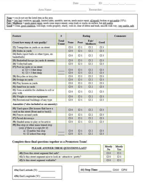
To ensure semantic and conceptual equivalence, the tools and supporting codebooks were simultaneously developed in English and Spanish with feedback received from both the promotoras and the project’s linguistics team. An adapted version of the Physical Activity Resource Assessment (PARA) (Lee et al., 2005) was used to assess street segments as PAPs in this study. In its original form, the PARA evaluates the quality and quantity of features, amenities, and incivilities of PAPs like parks, schools, and recreational facilities (Lee et al., 2005). Features (e.g., baseball field, exercise stations, play equipment) and amenities (e.g., access points, benches, landscaping efforts) are counted and then rated as “good,” “fair / mediocre,” “poor” regarding the overall appearance and utility for PA - possible scores range from 0-3 (none to good quality). Incivilities (characteristics that might deter PA; e.g. litter, no grass, vandalism) were rated on an ordinal scale based on the frequency of which the incivility was observed on the street segment (none, little, medium, a lot) (Lee et al., 2005).
Based on promotora feedback, several items were added or removed from the original PARA instrument to tailor the assessment for relevance to the setting or to adapt the instrument to assess streets as PAPs instead of traditional PA resources (e.g., parks, school grounds…). Original PARA items used to provide context of a PA resource, but not used to calculate QPAR scores, were removed as they did not pertain to streets (e.g., type of resource, approximate size, capacity, cost, and hours). Items were added to the street PAP assessment to indicate and describe presence of street characteristics often used to assess walkability or support for active transportation, such as speed limit, subjective traffic volume (low, medium, high), and street condition. Similar to the PARA, these items were not used to calculate the QPAR scores, but rather to describe the assessed street segments. Public place-oriented features, amenities, or incivilities assessed in the PARA, such as baseball fields, soccer fields, tennis courts, bathrooms, fountains, picnic tables, and locker rooms were removed as they are not likely present on streets or were not publicly accessible in this context (e.g., private household bathrooms). New features, amenities, and incivilities were added to those included in the PARA to capture features, amenities, or incivilities of yards and streets as PAPs and rating scales were adapted based on promotora feedback. At the end of the assessment, promotoras were also asked to report whether they perceived the street segment safe, nice to look at / attractive, and walkable; these were assessed using three separate, dichotomous (mostly yes / mostly no) questions. Please see the final English and Spanish PAP street assessment tools included as supplementary documents for final items and associated scoring categories in Appendix A.
Assessment Training
Promotora-researchers were trained by the research team on how to complete accurate assessments in a two-day, hands-on workshop with final protocol discussions and practice field assessments. During these practices, all promotoras and research team members assessed the same segments using the assessment forms to discuss count and quality ratings and discrepancies. Discrepancy identification allowed the research team an opportunity to address areas of confusion and further adapt the protocol. In-person booster trainings were conducted after promotoras had the opportunity to practice in the field. After training and booster trainings were completed, 3 traditional PAPs and segments were randomly selected for interrater reliability testing. Two promotoras independently completed the assessments, with 82.99% agreement in counts and ratings. Follow-up training with the promotoras was conducted to achieve consensus prior to proceeding with data collection.
Assessment Procedure
All assessments were completed by promotoras using Spanish versions of the forms. To ensure personal safety, promotoras completed all street-segment PAP and traditional local community PAP assessments in pairs and could complete street-segment assessments by walking or driving. To get an overall sense of the area, promotoras first drove the entire segment and, depending on safety (presence of stray dogs, vandalism, high traffic, etc.) or weather (rain, high temperatures, etc.), determined the safest way to complete the PAP street assessment. Once the assessment was completed, one promotora assessed the characteristics of the street and the incivilities, while a second promotora completed the PA feature and amenity sections before together answering the overarching perception questions as a team.
If the PAP street assessment was completed by walking, the team walked the segment twice. First, they walked down the street segment paying attention to the items they were each responsible for on the modified-PARA form. Then they turned around and walked the street segment again to complete the assessment form. However, if the assessment was completed by driving, then the team slowly drove the segment three times. The first time, they drove slowly down the entire segment paying attention to the items each was responsible for completing on the modified-PARA form. After the team identified which items they needed to assess further, a 2nd drive of the segment was completed to ensure correct counts and to make a quality rating for each item. Once at the end of the segment, the car was parked, and the entire assessment form was completed. Lastly, a 3rd drive was completed once the forms were finished to make certain no items or observations were missed.
Promotoras also completed PAP assessments for all traditional local community resources (e.g., parks, playgrounds, school grounds) on foot, capturing any and all that existed in the half mile radius of segments included in this study using the PARA protocol for traditional physical activity resources and calculating Quality Physical Activity Resource (QPAR) scores for each traditional PAP.
Data Analysis
Descriptive statistics including means, standard deviations, frequencies, and ranges were calculated using IBM SPSS v. 25. Frequencies as well as average quality of individual features, amenities, and incivilities were calculated. QPAR scores were also calculated for each street segment by adding the feature and amenity quality scores and subtracting the incivility quality score (possible scores = -24 to 63) (Lee et al., 2005). The same process was followed to calculate QPAR scores for local community-level PA resources assessed (e.g., parks, playgrounds; possible scores = -42 to 93). For visualization purposes, street PAPs and local community PA resources were classified as low, medium, or high quality by tertile rankings. Tertiles were calculated for each study region separately to assess relative quality more accurately for each region. Visualizations were created using ArcGIS ArcMap software v. 10.6 (ESRI, 2011).
To further describe streets in the context of a community’s PA resources, we examined distances between street segments and GIS-identified community-level PA resources, using ArcMap with documented GIS coordinates (ESRI, 2011). Streets were classified as being within a half-mile of a community-level PA resource or not. A half-mile radius was determined given evidence supporting positive associations between half-mile proximity to parks and PA behaviors (Bancroft et al., 2015). Independent t-tests were calculated to examine differences in street QPAR scores between street segments that had a community-level PA resource within a half-mile radius and those that did not. Independent t-tests were calculated using SPSS v.25 (IBM, 2018).
Results
It was feasible to use the adapted PARA methods to assess street segments as potential PAPs. Street segments (n=867) in 18 low-income areas along the Texas-Mexico border were assessed in this study. Eleven segments did not have accurate GIS coordinates (e.g., were located in another county, stretched across multiple areas) and were removed from further analysis involving GIS data, leaving 856 total street segments. When comparing these two areas, there were significant differences in street QPAR scores (t[854]=3.41; p<.001) between region 1 (M=17.88, SD=11.69) and region 2 (M=14.49, SD=8.63). There were also significant differences in the number of PAPs within a half mile (t[854]=12.14; p<.001) between streets in region 1 (M=2.15, SD=1.63) and region 2 (M=0.79, SD=1.23).
In describing the street segments at large, segments were a mean of 285.89 feet in length (SD=262.97). Only 17.9% of streets assessed (n=155) had posted speed limit signs, and of the streets with posted signs, 76.8% (n=119) had a speed limit of 30 miles per hour or less. Potholes were present in 25.7% of segments (n=223) and 33.7% of segments (n=292) were marked as having poorly maintained sections; however, 63.6% were marked as being in overall good condition. The majority (52.9%) of street segments (n=459) were evaluated as having low traffic volume, 28.5% (n=247) as having medium traffic volume, and 17.2% (n=149) as having high traffic volume. Street connectivity and pedestrian walking and cycling infrastructure (e.g., sidewalks, foot paths, street shoulders, cross walks) were seldom reported in these two areas. Promotoras perceived 38.1% of streets as mostly safe, 47.4% as mostly attractive, and 20.4% as mostly walkable. Table 2 displays the percent of street segments where traditional walkability street characteristics were present, as reported by the promotoras. Table 3 displays the frequency, mean frequency, and mean quality of all street segment features and amenities assessed. Table 4 displays the frequencies of each quality rating and the mean quality of all street segment incivilities assessed.
Table 2. Percentage of street segments with traditional walkability street characteristics (n=856)
|
Traditional Street Characteristics |
% of Streets |
|
Speed bumps |
11.9% |
|
Street connectivity |
0% |
|
Stop signs |
50.9% |
|
Curbs |
41.6% |
|
Ramps |
0% |
|
Foot paths |
0.1% |
|
Bike paths |
0% |
|
Sidewalks |
3.3% |
|
Street shoulders / emergency lanes |
8.5% |
|
Traffic lights |
3.5% |
|
Crosswalks |
5.0% |
|
Children at play signs |
17.9% |
|
Posted speed limits |
18.1% |
|
Paved street |
92.8% |
|
Good condition of street |
63.6% |
|
Low traffic volume |
53.7% |
|
Any Street Lights |
7.6% |
Table 3. Features and amenities of street segments as physical activity places (PAPs) using the PAP segment assessment (n=856)
|
Features |
Total Frequency |
Average Per Segment |
SD |
% of streets with |
Max |
Average Quality |
SD |
|
Trampoline in yards or on street1 |
544 |
0.63 |
1.08 |
37.1% |
5 |
2.47 |
0.67 |
|
Slides in yards1 |
460 |
0.53 |
0.84 |
36.3% |
5 |
2.54 |
0.59 |
|
Balls1 |
555 |
0.64 |
1.09 |
35.9% |
7 |
2.41 |
0.65 |
|
Basketball hoops (in yards & streets)1 |
676 |
0.78 |
1.22 |
42.6% |
11 |
2.46 |
0.65 |
|
Volleyball nets1 |
26 |
0.03 |
0.18 |
2.9% |
2 |
2.20 |
0.91 |
|
Pool < 3 feet1 |
243 |
0.28 |
0.67 |
19.6% |
6 |
2.72 |
0.51 |
|
Pool >3 feet1 |
165 |
0.19 |
0.51 |
15.3% |
4 |
2.86 |
0.42 |
|
Bicycles/tricycles1 |
1335 |
1.54 |
2.11 |
54.4% |
14 |
2.53 |
0.52 |
|
Swings in yards1 |
746 |
0.86 |
1.25 |
47.2% |
12 |
2.55 |
0.60 |
|
Play houses in yards1 |
416 |
0.48 |
0.83 |
33.7% |
6 |
2.54 |
0.60 |
|
Sand box in yards1 |
0 |
0.00 |
0.00 |
0.0% |
0 |
0.00 |
0.00 |
|
Tires to roll or play with1 |
52 |
0.06 |
0.41 |
3.6% |
9 |
2.61 |
0.56 |
|
Weight or exercise equipment1 |
104 |
0.12 |
0.36 |
10.5% |
4 |
2.40 |
0.74 |
|
Recreational buildings1 |
3 |
0.00 |
0.08 |
0.2% |
2 |
3.00 |
0.00 |
|
|
Total Frequency |
Average Per Segment |
SD |
% of streets with |
Max |
Average Quality |
SD |
|
Amenities |
|
|
|
|
|
|
|
|
Yard space (front and/or back)1 |
7308 |
8.43 |
8.46 |
85.9% |
44 |
2.79 |
0.41 |
|
Fences around yards1 |
5523 |
6.37 |
6.95 |
82.6% |
44 |
2.54 |
0.59 |
|
Paved driveways1 |
3147 |
3.63 |
4.88 |
70.4% |
30 |
2.55 |
0.60 |
|
Shaded areas to play or be active1 |
7057 |
8.14 |
8.25 |
85.6% |
44 |
2.55 |
0.54 |
|
Bus stop - Public1 |
0 |
0 |
0.00 |
0.0% |
0 |
0.00 |
0.00 |
|
Bus stop - School1 |
5 |
0.01 |
0.10 |
0.3% |
2 |
2.67 |
0.58 |
|
Yards well-maintained2 |
746 |
n/a |
n/a |
87.3% |
3 |
1.80 |
1.02 |
|
Street lighting3 |
65 |
n/a |
n/a |
7.6% |
3+ |
0.11 |
0.45 |
|
Note: 1Quality scores: None (0), Poor (1), Fair/Mediocre (2), Good (3) (Lee et al., 2005). 2Quality scores: None (0), Few (1), Several (2), A lot / Many (3). 3Quality scores: None (1), 1 (1), 2 (2), 3+ (3). |
|||||||
Table 4. Incivilities of street segments as physical activity places (PAPs) using the PAP segment assessment (n=856)
|
Incivilities |
None |
Little |
Medium |
A Lot |
Average Quality |
SD |
||
|
Litter/Trash on ground |
12.7% |
40.7% |
21.8% |
24.8% |
1.59 |
1.00 |
||
|
Graffiti |
65.7% |
15.3% |
8.8% |
10.2% |
0.63 |
1.01 |
||
|
Dogs loose on street |
50.4% |
13.6% |
30.3% |
5.7% |
0.91 |
1.02 |
||
|
Evidence of gang activity |
100.0% |
0.0% |
0.0% |
0.0% |
0.00 |
0.00 |
||
|
Police, Sheriff or Border Patrol cars, ICE |
95.1% |
4.4% |
0.4% |
0.1% |
0.05 |
0.257 |
||
|
Vandalism |
97.0% |
2.6% |
0.5% |
0.0% |
0.04 |
0.21 |
||
|
No grass |
72.7% |
16.4% |
9.9% |
0.9% |
0.39 |
0.70 |
||
|
Overgrown grass |
79.4% |
13.5% |
7.1% |
0.0% |
0.28 |
0.59 |
||
|
Note: Litter: Little < 5, Medium 5-10 pieces, A Lot = 11+ pieces; Graffiti: Little = 1-3 small, Medium = 4+ small, A lot = 1+ large; All other incivilities: Little = 1, Medium = 2-4, A lot = 5+ |
|
|||||||
Bicycles were the most common feature observed on street segments, 54.4% of street segments had bicycles present. Swings were observed on 47.2% of street segments and 42.6% of segments had basketball hoops. On average, street segments had 6.10 (SD=7.20) features which were evaluated to be of good-to-fair quality (M= 2.50; SD=0.50) and 27.65 (SD=27.65) amenities evaluated to be of good-to-fair quality (M= 2.60; SD= 0.40). In total, 86.0% of streets contained at least one amenity and 156 amenities were the greatest number observed on any one segment. Yard space was the most common amenity observed on street segments; 85.9% of street segments had at least one household with yard space. Shaded areas were observed on 85.6% of street segments and 70.4% of segments had paved driveways.
Litter was the most common incivility observed on street segments; 87.4% of street segments had litter (n=758). Almost a quarter of street segments (24.5%, n=212) had more than 11 items of litter while 40.1% (n=348) had little litter defined as fewer than five items. Loose, unleashed dogs were observed on 50.3% of street segments and 27.3% of streets had lots without grass. On average, street segments had 3.50 (SD=2.40) incivilities. In total, 94.5% of streets contained at least one incivility, with low rates of “a lot” of any incivility reported.
Figure 1: Region #1 street segments and local community physical activity (PA) resources
Figure 2: Region #2 street segments and local community physical activity (PA) resources
Discussion
This study presents an innovative approach to assessing streets as potential PAPs and describes PAP characteristics that streets provide in low-income communities, often with fewer and less accessible traditional community PAPs. With the previously mentioned disparities in PAPs found in lower socioeconomic status communities (Bantham et al., 2021; Romero, 2005; Sallis et al., 2011), considering street segments as potential places for PA may help researchers and practitioners have a more complete picture of potential places for PA promotion that are accessible to more community members. Streets are being used for temporary PA interventions like Ciclovía, open streets, and Play Streets initiatives in urban, suburban, and rural communities (Kuhlberg et al., 2014; Perry et al., 2017; Umstattd Meyer, Bridges, et al., 2019; Umstattd Meyer, Bridges Hamilton, et al., 2019), but prior to this study the quality and quantity of PAP features and amenities on streets, outside of walkability, have not been examined.
Results from the high-level descriptive assessment of walkability characteristics of the streets included in this study revealed that many characteristics supportive of walkability and active transportation were rarely present in these low-income communities (e.g., connectivity, sidewalks; see Table 2). Better understanding a community’s infrastructure as it pertains to all types of PA is a recommended next step. Specifically, more robust measures of walkability and active transport characteristics should be used alongside the PAP street assessment to gauge street support for overall PA - walking, cycling, active transportation, and leisure time PA and active play. In addition, to build a more complete picture of community PA-supports for residents, future research should include a more comprehensive picture of quantity and quality of PA-promoting infrastructure and resources accessible to residents. In this study, the inclusion of presence of traditional community PAPs within a 1/2 -mile radius begins this conversation; however future work should also incorporate quality of these traditional community PAPs and policy and programmatic supports. Researchers also need to determine meaningful and accessible ways for community members, practitioners, and decision makers to use this data to inform PA-related infrastructure, policy, and programmatic decisions.
Further, evaluating streets and the accompanying spaces as PAPs goes above and beyond past measurement tools to understand the features and amenities present within the community that may be accessed on a family or residential level. Research has indicated that parents are more likely to allow children to play outside in more proximal areas. Having features and amenities that promote PA within their home space or yard would provide more opportunities for families to be active. However, for this to be a valid intervention approach or recommendation, researchers first need to understand the presence or availability of such resources. MAPS and other street, sidewalk, or transit-based assessments may not account for other PA-related elements vital for PA (Crawford et al., 2010; Hunter et al., 2020; Veitch, Hume, Salmon, Crawford, & Ball, 2013).
PA-promoting features and amenities were frequently observed on street segments in this study, with bicycles the most commonly observed feature. Bicycling is seen as an active transport method as well as a leisure-time activity but can be deterred by other street level characteristics like connectivity, traffic level, traffic speed, and fear of crime (Stewart, Vernez Moudon, & Claybrooke, 2012). In this study, if the only assessment of cycling support would have been the presence of bike lanes or connectivity, it would have easily been concluded that cycling was not occurring in these communities. However, using this information in conjunction with the PAP street assessment data, we can conclude that there is evidence of cycling as PA in these communities. A next step would be to collect additional information to understand where and why cycling is occurring and safety needs, to better inform PA-promotion and community needs. This underlines the importance of street level characteristics in relation to PA-promoting features in neighboring yards and how these features can support child and adult PA. Yard space was the most commonly observed amenity, which may be important for children residing in these communities as time spent outdoors is a significant predictor of at-home child PA; yard space could provide safe outdoor play and/or PA space (Sallis et al., 1993), especially if families do not perceive there to be other safe places for PA in the area (Prochnow, Pickett, Gómez, Sharkey, & Umstattd Meyer, 2021).
The observed presence of incivilities on streets could help explain why promotoras perceived only 38.1% of streets as safe and 47.4% as attractive. The perception of safety is associated with greater adolescent PA and family PA in neighborhoods as well as in parks (Esteban-Cornejo et al., 2016). Traffic speed and volume are also negatively related with child PA, which could have further influenced the promotoras’ perceptions of street segment safety, even with 53.7% of the segments rated as having “low traffic volume” (Luo et al., 2020). The information collected in this street segment PAP assessment provides information on both potential PA supports available on street segments (features and amenities), while also providing information on potential barriers that might prevent or discourage the use of these supporting PAP characteristics (incivilities, traffic, and lack of perceived safety). While our team supported the addition of three incivility items (evidence of gang activity, police, sheriff or border patrol cars, ICE, and loose dogs on streets), no evidence of gang activity was reported and the inclusion of presence of law enforcement as an incivility was specific to the context of the present study. Future studies should consider context in adding, adapting, or removing items from current tools. In the instance of this study, the promotoras held knowledge of community members’ fear of deportation and law enforcement and felt it important to capture this as a possible barrier to residents using streets for PA. Future researchers and practitioners need to take the time to fully understand how the presence of contextual characteristics, including law enforcement, might support or impede PA participation in their communities, recognizing that the direction of these relationships might differ by community.
Programs and initiatives which temporarily activate streets as PAPs, such as Play Streets and Ciclovías (Pollack Porter et al., 2019; Umstattd Meyer, Bridges Hamilton, et al., 2019), may be exceptionally beneficial for communities without as many traditional community-level PA resources like parks or for communities where these traditional community-level PAPs aren’t very accessible due to longer driving distances or lack of resources for maintenance, which is often the case in low-income areas (Bantham et al., 2021; Sallis et al., 2011). In this sense, Play Streets or a Ciclovía would temporarily close a street segment to open a safe place for children to play and all residents to be active in the street and neighboring yards. These initiatives may also promote a greater sense of social connection and cohesion within the community (Umstattd Meyer et al., 2021) which in turn may foster more PA (Prochnow, Umstattd Meyer, et al., 2021). Using a PAP street assessment such as the one described in the present study would highlight current street PAP characteristics to consider in planning for these types of initiatives (e.g., using PAP street assessment data to identify which areas within a community there are more youth associated play equipment present indicating where youth live and the types of PA equipment for which local youth have access that can be incorporated into initiative planning), which streets could more easily support this type of temporary initiative (e.g., lower speed limits and less traffic indicating it could be less burdensome to temporarily stop vehicular traffic for the initiative), and streets that could benefit the most from these types of temporary activations given proximity to community-level PA resources. Using street PAP scores can indicate areas that could benefit from a place-based initiative (lower scores) and provides information to help identify the most feasible and supportive streets for these initiatives (lower speed limits, less traffic).
Future research would also benefit from assessing community members’ perceptions of street-level PAP features, amenities, and incivilities to use in combination with this type of street PAP observational assessment. This approach has recently been included with more traditional community-level PAPs to help communities identify areas for current PA-promotion initiatives and prioritize future advocacy efforts (Umstattd Meyer, Ylitalo, Prochnow, Gómez, & Sharkey, 2020).
Limitations
Generalizability of these findings may be difficult due to the nature of the sample. Although colonias can be found along the U.S.-Mexico border and in states other than Texas, perceptions based on location could differ (Umstattd Meyer et al., 2016). For example, residents from these communities may have different perceptions regarding PAPs when compared to a low-income community in a different state or region. Community perceptions can also differ due to cultural, ethnic, and/or racial uniqueness, which need to be acknowledged and understood. In the present study, PAP street assessments were conducted by promotoras from the study communities; however, assessments were not completed by the residents of the assessed streets, who could have had different views than the promotoras. It should be noted that the regions used in this study were significantly different in terms of QPAR scores and street proximity to traditional PAPs. While this could be viewed as a limitation in the sample, it may also show the utility of such measurement when factoring in the non-significant difference in QPAR scores between streets within a half-mile from a PAP and those farther away.
Conclusions
Streets could be one of the few existing and/or accessible places for PA in some low-income communities. In this study, streets did contain features and amenities which could promote PA. Future PA programming should consider ways to safely incorporate streets as PAPs to enhance PA and active play for children and families. Future work should examine residents’ perceptions of PAP characteristics when considering their streets as potential places for PA and active play, beyond walking and active transport. In moving forward, PAP street assessment data needs to be combined with overall community-level PA data, street walkability and active transport data, and community members’ perceptions to better inform PA initiatives.
Correspondence should be addressed to
M. Renée Umstattd Meyer, Ph.D.
Baylor University
Robbins College of Health & Human Sciences
One Bear Place #97303
Waco, TX 76798
(254)-710-4029
![]() M.
Renée Umstattd Meyer: 0000-0001-5525-943X
M.
Renée Umstattd Meyer: 0000-0001-5525-943X
![]() Tyler
Prochnow: 0000-0001-7886-4456
Tyler
Prochnow: 0000-0001-7886-4456
![]() Kelly
R. Ylitalo:
0000-0002-1474-6781
Kelly
R. Ylitalo:
0000-0002-1474-6781
![]() Joseph
R. Sharkey: 0000-0001-5289-4630
Joseph
R. Sharkey: 0000-0001-5289-4630
Funding
This work is supported by Competitive Grants Program, Childhood Obesity Prevention Challenge Area, Grant no. 2015-68001-23234 from the USDA National Institute of Food and Agriculture. Any opinions, findings, conclusions, or recommendations expressed in this publication are those of the author(s) and do not necessarily reflect the view of the U.S. Department of Agriculture.
Acknowledgements
We gratefully acknowledge the promotora-researchers, whose time, effort, and willingness made this project possible. Specifically, we want to acknowledge the time and leadership of our research team and promotora-researchers Elva Beltran, Mayte Garza, Luz Martinez, and Tomas Johanson.
Conflict of interest
We have no conflicts of interest to disclose.
Author Contributions
Conceptualization, M.R.U.M., T.P., K.R.Y., J.R.S.; Methodology, M.R.U.M., T.P., K.R.Y.; Investigation, M.R.U.M., L.G., J.R.S.; Writing – Original Draft, M.R.U.M., T.P.; Writing – Review & Editing, M.R.U.M., T.P., K.R.Y., L.G., J.R.S.; Funding Acquisition, M.R.U.M., J.R.S.; Resources, M.R.U.M., J.R.S.; Supervision, M.R.U.M., L.G., J.R.S.
Creative Commons License
This work is licensed under a Creative Commons Attribution-Noncommercial 4.0 International License (CC BY-NC 4.0).
References
Armstrong, S., Wong, C. A., Perrin, E., Page, S., Sibley, L., & Skinner, A. (2018). Association of Physical Activity With Income, Race/Ethnicity, and Sex Among Adolescents and Young Adults in the United States: Findings From the National Health and Nutrition Examination Survey, 2007-2016. JAMA Pediatrics, 172(8), 732-740. doi:10.1001/jamapediatrics.2018.1273
Bancroft, C., Joshi, S., Rundle, A., Hutson, M., Chong, C., Weiss, C. C., . . . Lovasi, G. (2015). Association of proximity and density of parks and objectively measured physical activity in the United States: A systematic review. Social Science and Medicine, 138, 22-30. doi:https://doi.org/10.1016/j.socscimed.2015.05.034
Bantham, A., Taverno Ross, S. E., Sebastião, E., & Hall, G. (2021). Overcoming barriers to physical activity in underserved populations. Progress in Cardiovascular Diseases, 64, 64-71. doi:https://doi.org/10.1016/j.pcad.2020.11.002
Clifton, K. J., Smith, A. D. L., & Rodriguez, D. (2007). The development and testing of an audit for the pedestrian environment. Landscape and Urban Planning, 80(1-2), 95-110.
Crawford, D., Cleland, V., Timperio, A., Salmon, J., Andrianopoulos, N., Roberts, R., . . . Ball, K. (2010). The longitudinal influence of home and neighbourhood environments on children's body mass index and physical activity over 5 years: the CLAN study. Int J Obes (Lond), 34(7), 1177-1187. doi:10.1038/ijo.2010.57
DeBate, R. D., Koby, E. J., Looney, T. E., Trainor, J. K., Zwald, M. L., Bryant, C. A., & McDermott, R. J. (2011). Utility of the Physical Activity Resource Assessment for Child-centric Physical Activity Intervention Planning in Two Urban Neighborhoods. Journal of Community Health, 36(1), 132-140. doi:10.1007/s10900-010-9290-1
Donelson, A. J., & Esparza, A. X. (2010). The colonias reader: Economy, housing, and public health in U.S.-Mexico border colonias. Donelson AJ, Esparza AX, Tuscon, AZ: The University of Arizona Press.
ESRI. (2011). ArcGIS Desktop 10.6. Redlands, CA: Environmental Systems Research Institute.
Esteban-Cornejo, I., Carlson, J. A., Conway, T. L., Cain, K. L., Saelens, B. E., Frank, L. D., . . . Sallis, J. F. (2016). Parental and Adolescent Perceptions of Neighborhood Safety Related to Adolescents' Physical Activity in Their Neighborhood. Research Quarterly for Exercise and Sport, 87(2), 191-199. doi:10.1080/02701367.2016.1153779
Hoehner, C. M., Ivy, A., Ramirez, L. K. B., Handy, S., & Brownson, R. C. (2007). Active neighborhood checklist: a user-friendly and reliable tool for assessing activity friendliness. American Journal of Health Promotion, 21(6), 534-537.
Hunter, S., Carson, V., Timperio, A., Salmon, J., Carver, A., & Veitch, J. (2020). Moderators of Parents’ Perceptions of the Neighborhood Environment and Children’s Physical Activity, Time Outside, and Screen Time. Journal of Physical Activity and Health, 17(5), 557-565. doi:10.1123/jpah.2019-0433
IBM. (2018). IBM SPSS Statistics for Windows Version 25. Armonk, NY: IBM Corp.
Janssen, I., & LeBlanc, A. G. (2010). Systematic review of the health benefits of physical activity and fitness in school-aged children and youth. International Journal of Behavioral Nutrition and Physical Activity, 7(1), 40.
Johnson, C. M., Sharkey, J. R., Dean, W. R., St John, J. A., & Castillo, M. (2013). Promotoras as research partners to engage health disparity communities. J Acad Nutr Diet, 113(5), 638-642. doi:10.1016/j.jand.2012.11.014
Kann, L., McManus, T., Harris, W. A., Shanklin, S. L., Flint, K. H., Queen, B., . . . Ethier, K. A. (2018). Youth Risk Behavior Surveillance - United States, 2017. MMWR Surveillance Summary, 67(8), 1-114. doi:10.15585/mmwr.ss6708a1
Kuhlberg, J. A., Hipp, J. A., Eyler, A., & Chang, G. (2014). Open streets initiatives in the United States: closed to traffic, open to physical activity. Journal of physical activity and health, 11(8), 1468-1474.
Lee, R. E., Booth, K. M., Reese-Smith, J. Y., Regan, G., & Howard, H. H. (2005). The Physical Activity Resource Assessment (PARA) instrument: evaluating features, amenities and incivilities of physical activity resources in urban neighborhoods. Int J Behav Nutr Phys Act, 2, 13. doi:10.1186/1479-5868-2-13
Luo, M., Li, H., Pan, X., Fei, T., Dai, S., Qiu, G., . . . Jia, P. (2020). Neighbourhood speed limit and childhood obesity. Obesity Reviews, n/a(n/a). doi:10.1111/obr.13052
Office of Global Affairs. (2017). The U.S.-Mexico border region. Retrieved from https://www.hhs.gov/about/agencies/oga/about-oga/what-we-do/international-relations-division/americas/border-health-commission/us-mexico-border-region/index.html
Perry, C. K., Ko, L. K., Hernandez, L., Ortiz, R., & Linde, S. (2017). Ciclovia in a Rural Latino Community: Results and Lessons Learned. Journal of Public Health Management and Practice, 23(4). Retrieved from https://journals.lww.com/jphmp/Fulltext/2017/07000/Ciclovia_in_a_Rural_Latino_Community__Results_and.6.aspx
Pollack Porter, K. M., Prochnow, T., Mahoney, P., Delgado, H., Bridges Hamilton, C. N., Wilkins, E., & Umstattd Meyer, M. R. (2019). Transforming city streets to promote physical activity and health equity. Health Affairs, 38(9), 1475-1483. doi:10.1377/hlthaff.2019.00454
Prochnow, T., Pickett, A. C., Gómez, L., Sharkey, J., & Umstattd Meyer, M. R. (2021). Maternal Perceptions of Physical Activity Spaces for Children in Texas Border colonias. Hispanic Journal of Behavioral Sciences, 07399863211044887. doi:10.1177/07399863211044887
Prochnow, T., Umstattd Meyer, M. R., Patterson, M. S., Trost, S. G., Gómez, L., & Sharkey, J. (2021). Active Play Network Influences on Physical Activity Among Children Living in Texas Colonias. Family and Community Health, 44(3), 154-161. doi:10.1097/fch.0000000000000296
Romero, A. J. (2005). Low-income neighborhood barriers and resources for adolescents’ physical activity. Journal of Adolescent Health, 36(3), 253-259. doi:https://doi.org/10.1016/j.jadohealth.2004.02.027
Sallis, J. F., Nader, P. R., Broyles, S. L., Berry, C. C., Elder, J. P., McKenzie, T. L., & Nelson, J. A. (1993). Correlates of Physical Activity at Home in Mexican-American and Anglo-American Preschool Children. Health Psychology, 12(5), 390-398. doi:10.1037/0278-6133.12.5.390
Sallis, J. F., Slymen, D. J., Conway, T. L., Frank, L. D., Saelens, B. E., Cain, K., & Chapman, J. E. (2011). Income disparities in perceived neighborhood built and social environment attributes. Health & Place, 17(6), 1274-1283. doi:https://doi.org/10.1016/j.healthplace.2011.02.006
Sharkey, J. R., & Horel, S. (2008). Neighborhood socioeconomic deprivation and minority composition are associated with better potential spatial access to the ground-truthed food environment in a large rural area. Journal of Nutrition, 138(3), 620-627. doi:10.1093/jn/138.3.620
St. John, J. A., Johnson, C. M., Sharkey, J. R., Dean, W. R., & Arandia, G. (2013). Empowerment of promotoras as promotora–researchers in the Comidas Daludables & Gente Sana en las Colonias del Sur de Tejas (Healthy Food and Healthy People in South Texas Colonias) program. J Prim Prev, 34(1), 41-57. doi:10.1007/s10935-013-0296-1
Stewart, O., Vernez Moudon, A., & Claybrooke, C. (2012). Common ground: Eight factors that influence walking and biking to school. Transport Policy, 24, 240-248. doi:https://doi.org/10.1016/j.tranpol.2012.06.016
Umstattd Meyer, M. R., Bridges, C. N., Schmid, T. L., Hecht, A. A., & Pollack Porter, K. M. (2019). Systematic review of how Play Streets impact opportunities for active play, physical activity, neighborhoods, and communities. BMC Public Health, 19(1), 335. doi:10.1186/s12889-019-6609-4
Umstattd Meyer, M. R., Bridges Hamilton, C. N., Prochnow, T., McClendon, M. E., Arnold, K. T., Wilkins, E., . . . Pollack Porter, K. M. (2019). Come together, play, be active: Physical activity engagement of school-age children at Play Streets in four diverse rural communities in the U.S. Preventive Medicine, 129, 105869. doi:10.1016/j.ypmed.2019.105869
Umstattd Meyer, M. R., Moore, J. B., Abildso, C., Edwards, M. B., Gamble, A., & Baskin, M. L. (2016). Rural Active Living: A Call to Action. Journal of public health management and practice : JPHMP, 22(5), E11-20. doi:10.1097/PHH.0000000000000333
Umstattd Meyer, M. R., Prochnow, T., Pickett, A. C., Perry, C. K., Bridges Hamilton, C. N., Abildso, C. G., & Pollack Porter, K. M. (2021). The Effects of Play Streets on Social and Community Connectedness in Rural Communities. International Journal of Environmental Research and Public Health, 18(19). doi:10.3390/ijerph18199976
Umstattd Meyer, M. R., Ylitalo, K. R., Prochnow, T., Gómez, L. A., & Sharkey, J. R. (2020). Physical activity Space Methodology for Assessment and Prioritization (PASMAP): Combining systematic observations with community perceptions to identify community physical activity resource priorities. Health & Place, 66, 102443. doi:https://doi.org/10.1016/j.healthplace.2020.102443
US Census Bureau. (2019). American Community Survey Data. Retrieved from: https://data.census.gov/
Veitch, J., Hume, C., Salmon, J., Crawford, D., & Ball, K. (2013). What helps children to be more active and less sedentary? Perceptions of mothers living in disadvantaged neighbourhoods. Child: Care, Health and Development, 39(1), 94-102. doi:10.1111/j.1365-2214.2011.01321.x
Villarroel, M., Blackwell, D., & Jen, A. (2019). Tables of Summary Health Statistics for U.S. Adults: 2018 National Health Interview Survey. Retrieved from http://www.cdc.gov/nchs/nhis/SHS/tables.html
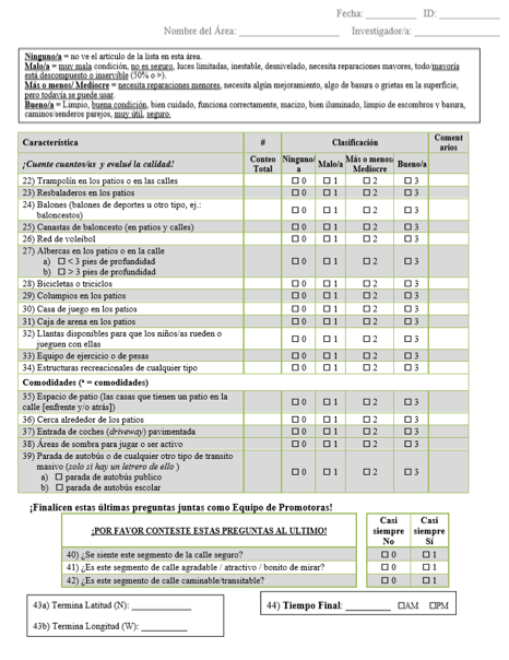
Appendix A
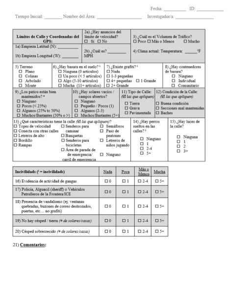
Street Segment Physical Activity Place (PAP) Tool
(English)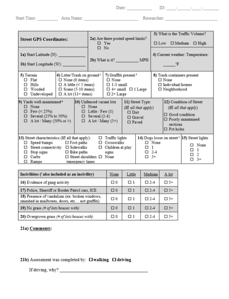
Street Segment Physical Activity Place (PAP) Tool (Spanish)